Brochures:
Company's Profile
PHOTOGRAMMETRY
Photogrammetry allows you to make reliable measurements of physical objects and landscape from photographs, refine them and apply them in GIS creation, mapping and topographic 3-D models of terrains. Input data are obtained from Aerial Photography, and Satellite Imagery. Services offered cater to versatile needs viz. Municipal Mapping, City Modelling, Utilities Mapping and more.
Dr Design India brings best-in-class aerial photogrammetry and digital photogrammetric services to its clients worldwide. From consulting to data acquisition and processing for integration-let Dr. Design India handle your photogrammetric needs with simplicity and expertise.
Photogrammetric Services offered
- Satellite Imagery.
- Aerial Imagery and Aerial Photogrammetry.
- 3D Modelling
- Unmanned Aerial Vehicles (UAV).
- Context Reality.
Satellite Imagery
We partner with global leaders using the most sophisticated satellite technology for capturing high resolution satellite imagery – including both 2D & 3D images, which are further orthorectified by our specialists to furnish accurate DEMs and 3D Terrain Models.
These deliverables provide invaluable information to a broad spectrum of industries such as Urban Development, Oil and Gas, Mining, Pipeline Corridor Mapping, Forestry to name a few.
Aerial Imagery and Aerial Photogrammetry
Dr Design India endeavors to provide to its customers the best services and to this end, we partner with the global leaders to access a fleet of superior manned aircrafts for all the aerial imagery needs across the globe.
We also own powerfully equipped state-of-the-art UAV systems to deliver low-altitude high-definition imagery.
Whether it is a Government entity or a Civil Engineering Company needing accurate terrain information for a major infrastructure project, Dr. Design India has the experience, expertise and resources to render an economical, fit-for-all-purpose solution.
Aerial Imagery finds its applications in:
- Local governments for smart urban planning.
- Mining companies to survey dangerous or inaccessible areas.
- Engineering and construction firms to get key insights for planning major infrastructure projects.
- Disaster Management to assess environmental damage caused by natural disasters and strategizes future mitigation measures.
Aerial Photogrammetry finds its applications in:
- Design of Land Use Maps
- Accurate mapping and surveying to create 3D city models
- Topographic mapping
3D Modelling
3D modelling finds a huge relevance in the contemporary industries & business houses for designing & analysis of products & services. 3D models are preferred to graphical object and find their applications in medical industry which relies on 3D organ modelling, the construction firms which use them to display their proposed landscaping & facilities and the movie industry to describe characters in the animated motion pictures.
The data source for any kind of 3D model is point coordinates from the surface of the structure or object. Dr. Design India employs specialized software solutions to convert the images obtained from aerial imagery into a highly accurate, sophisticated 3D model.
Key features include:
- Requires a considerably short time to capture an on-site image
- Images can be captured from a distance, thus being a ‘non-touch’ technology, it can be considered for use in risky or inaccessible places
- No large scale equipment needed
- Resultant constructed model gives a more photo-realistic texture
LI DAR Engineering
Dr. Design India offers professional Terrestrial and Airborne LiDAR services that help map physical features with stunning resolutions. LiDAR technically uses a pulsed laser to measure topographic measurements of the earth’s surface. The reflected laser pulses coupled with other aerial digital imagery is assembled to produce a highly accurate and detailed 3-D image of the facility / landscape under consideration.
Airborne LiDAR
- Flight Line Adjustments.
- Building Extractions.
- Contour Generation.
- Bare earth Extraction.
- Advanced as-built 3D Modelling.
- Planimetric Mapping
Various details of the exterior and interior of the landscape or facility can be modelled using 3-D scans. Some of the applications of LiDAR include:
- Extremely accurate and detailed 3-D models of transmission lines.
- For analysis of road structure and elevation of highways, rail tracks etc. through Mobile LiDAR.
- Mapping the underside of bridges with the aid of a boat mounted LiDAR system.
- Scanning the interiors of buildings and structures to centimeter accuracy.
- Surveying in areas with remoteness and low accessibility.
- Inspection and mapping in dangerous and rough terrain viz. disaster prone areas
Mobile LiDAR
Dr. Design India offers you the next big thing – LiDAR systems mounted on UAVs that are not just light-weight and compact but also don’t compromise on point cloud resolution and positional accuracy. These are completely integrated systems and quick to deploy on the field.
Unmanned Aerial Vehicles (UAV)
The last decade witnessed a splurging use of UAVs in almost every field, ranging from the military to the consumer and commercial sectors. The capability and accuracy of UAVs in surveillance and site inspection has been overwhelming and Dr. Design India is proud to offer UAV Services with latest cutting edge technology at your disposal. Our UAVs capture accurate and highly detailed Ortho-Photographs, 3D Digital Elevation Models, NDVI maps and more.
Context Reality
Dr Design India employs specialized software to fabricate high resolution digital 3D models from simple photographs. Geographic features can be sufficiently captured with just a camera and the photographs obtained can be fed into software to produce an intelligent Reality Model.
Applications vary from 3D city scale mapping and photorealistic model of construction site to capturing the fine details of excavation sites, sculptures from simple photographs taken on field to even investigating a crime scene from all perspectives.
Few of the key features of this service offering are:
- Superior Precision
- High Performance
- CAD and GIS Interoperability
- Unlimited Scalability

Geographic Information System (GIS)
We are an Independent GIS System Integrator and focuses on end to end offerings in geospatial information services. Our offerings includes GIS Consultancy Services, GIS System Development & Implementation, off-the-rack Integration, Testing & Maintenance for various verticals, GIS Data Design & Modelling, Data Migration, Capture, Validation, Maintenance (including remote maintenance), customer application development, web-based GIS for internal project management & for external customers, Geodatabase design configuring RDBMS establishing a multiuser editing environment, Standalone and web/mobile GIS application development.
We offers Geospatial services for Telecom, Electric, Water & Sewer, Waste water, Gas, Land base and all other Utility Domain
GIS Data Conversion
The increasing role of spatial information has contributed to an ever-increasing set of standards and range of data formats for use. Different computer systems employ source data in dissimilar formats. With Dr. Design India’s leading data conversion software, data interoperability is no longer a tedious job.
Incompatible data formats can be a big challenge when migrating data across applications, this includes data that is non-digital (paper maps and other similar sources) and digital but in a different format. Our experienced team takes care of both these needs.
With the help of efficient software, analog data in the form of maps, reports and charts is scanned, manually digitized and converted into a standard GIS format. Non-traditional GIS data, such as satellite imagery, orthophotographs and digital terrain data which is often tedious to combine with GIS systems but yet is of an enormous value is seamlessly converted to an acceptable format that can be rendered by most common tools.
At Dr. Design India, we believe that quality management must work alongside all work relating to GIS management. For use data conversion doesn’t stop at changing formats and making data more compatible for the next computer system or application software, but we guarantee that quality practices are meticulously followed and business standards are maintained.
GIS Geodatabase Design, Development & Management
Dr. Design Indiahas guided several clients from outdated file based GIS systems to highly scalable, high performance and secures Geo-database implementations. We provide expertise and consulting in the most sought after Geo-database architectures.
Along with design, Dr. Design India provides support and maintenance services for geodatabases that include periodic enhancements to ensure updated version of the geographic assets to reflect topographic changes in the real world.
Geospatial Data warehouse and Data Mining
At Dr. Design India, we implement DWH solutions for enterprises with spatial and administrative data integrated together to help increase their business value.
Spatial data in large volumes can often be redundant. It is extremely important to derive crucial findings from effective analysis of such data to facilitate effective utilization of time and prevent operational delays.
Dr. Design India offers a complete DWH solution that not only involves storing and retrieving of spatial data, but also analyzes, reports and presents it based on specific business value.
Open Source SDI
Dr. Design India introduces some of the amazing open source Spatial Data Infrastructure available. There is much more to an SDI than just a standalone desktop or web GIS application.
SDI is a framework of geographic data, technologies, metadata, institutional arrangements and standards that facilitate the creation, exchange and use of geospatial data across an information-sharing community. This community can be at an organization level, national level or global level.
In all cases, SDI facilitates a standardized, automated means of evaluating and exchanging crucial geospatial information and other related resources.
Enterprise Web GIS
‘Dr. Design India for Enterprise’ is a platform offering a complete GIS solution that runs on your infrastructure, behind your firewall and is integrated seamlessly with your enterprise systems and complies with your standards.
With the web version, the platform is hosted on a cloud which means syncing and exchange of crucial geographic information can happen on the go, without the need to handle cumbersome server maintenance and disposal.
Implementing Enterprise GIS in your organization’s core functioning has two central advantages. One is the exchange and use of crucial geospatial information across groups, departments and offices. It allows all your staff to tap into the power of geospatial analytics. Second is the integration of this data with various important enterprise software such as SAP, Billing Systems etc. that might use a spatial component for analysis to derive data holding significant business value.
Urban Master Planning
Dr. Design India is a proud pioneer in the field of urban master planning for smart cities. From strategic city landscape planning to detailed local area plans, we ensure that all perspectives for topographical assessment are captured.
The assessment is made on various factors such as transportation plan, strategic land use and optimal disbursing of public services. Likewise, details such as population density and industrial fields are taken into account.
The findings are laid out in the form of a master plan that would guide the development of the city for years to follow.
GIS MIS Integration
An enterprise cannot function effectively if an optimal flow/exchange of information is missing. This is where MIS comes to rescue. Management Information Systems facilitate operation of crucial data repositories that hold data of significant business value. This data can be used by groups, divisions or departments within the enterprise based on business requirements, or for knowledge sharing and use of best practices in general.
Integrating GIS with MIS takes ICT to the next level. There is no questioning the significance of geo-spatial data for businesses today. Location can be an important variable in understanding trends and tracking real time data.
Moreover, it has enormous value for lines that require monitoring of territories and analyzing trends. For instance, a forest department might wish to track and analyze details such as forest fires, encroachment, animal injury, man-animal conflict and more- all in real time. This can be made possible with the aid of GIS enabled smart phones or portable devices to track the location and a GIS-MIS System to view, track and analyze the findings.

SURVEYS
At Dr. Design India, surveying is done for the trickiest sites with a team of in-house surveyors, engineers and regulatory staff.
Land Surveying is cited as both an art and science. It requires good scientific acumen, use of latest technology in surveying and data processing and a knowledge of common real estate law prevalent in the State.
Follow our surveyors on the field, and you shall be a witness to the most advanced equipment used for the tasks underhand, and extreme detailing and precision to achieve results that you can count on. Walk into our office and you could explore a versatile range of sophisticated software tailored for different industries and solutions. Our analysts have good expertise and experience in GIS, applications programming, database automation, spatial modelling and 3D modelling.
Topographical Survey
Topographical survey identifies and maps spatial features and contours of the terrain or earth structure.
We, at Dr. Design India deliver a rich & detailed plan with the building architecture, paved areas, spot heights & contours, trees & drip lines and legal boundaries. The maps furnished are an important building block for the building or site under construction.
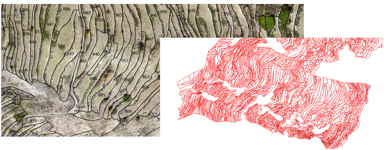
Cadastral Survey
Cadastral Survey refers to the survey and demarcation of land to define legal property boundaries. This type of survey mandates professional registration in all states.
Regardless of the size of the topographic area or the complexity of the project, Dr. Design India possesses the experience to develop unique tailor-made solutions for any land related matter. Some of the applications of cadastral survey involve its use in construction layout services, road widening projects and creation of utility corridors.
Following are few of the chores relating to Cadastral Survey:
- Boundary Identification: Establishing monuments or markers to define and hence preserve the boundaries of land belonging to a private body, corporation or the government.
- Existing Survey Assessment: Verifying and relocating existing markers and monuments by examining previous surveys and reestablishing new data if obtained.
- Subdivision of land: Subdividing landed estates into parcels of predetermined sizes and shapes.
- Assess your land ownership well before investing into the big real estate project- give us a call today to know more.
Route Survey
Quality Route Survey is an important benchmark for infrastructure improvements such as railroads, highways, open-conduit systems, pipelines and canals.
The surveyors gather significant information for the proposed route of a highway / railway / utility pipeline to find the most conducive & cost effective route to follow. Dr. Design India delivers high quality route surveying services with systematic planning.
Utility and Engineering Survey
Utility Survey has been very effective in safeguarding people from accidents resulting from damage of utilities buried underground / concealed within concrete structures which can otherwise be very serious and fatal.
Dr. Design India offers highly specialized asset mapping, utility detection and site investigation services using the latest ground-penetrating radar (GPR), MIRA and electromagnetic techniques.
Some of the scenarios where Utility Survey has been applied include:
- During the installation of a new pipe-line, accurate information of the existing pipeline network is very crucial.
- Attending to complaints of leakages or other unforeseen circumstances where a detailed map of utility network serves as a quick fix solution.
- For assessing the risk of the network under consideration in order to ensure public safety.
- For construction work involving piling, deep foundations and more.
Control Survey
To ensure practical use, the relationship between a topographical map and the real world must be clear and accurate. For this reason, information such as scale, orientation and height must be known w.r.t standard reference points. A Survey Control determines the position (latitude, longitude and height) of features that can be seen on the map.
Modern maps are mostly developed from overlapped images taken from aircrafts (aerial photography) or digital images obtained from satellites (satellite imagery). A Survey Control not only scales and orients these maps, but also removes any distortions retained in the imagery.
Dr. Design India offers the following Control Surveys for your geospatial needs:
- Horizontal Corridor Control Surveys
- Horizontal Project Control Surveys
- Vertical Project Control Surveys
- Supplemental Control
Urban Planning / Property Survey
Successful Urban Planning is a combination of good understanding of the local, state and national legislation, use of modern technology for land profiling and surveying and an excellent team of engineers to design the plan.
At Dr. Design India, a combination of these applied meticulously allows us to deliver award winning service solutions.
We have catered to the design and assessment of urban master-planned communities worldwide that include:
- Residential Communities and Mixed Use Townships
- SEZs and Business Districts
- Public Transport Networks
- Environmental Design of Regional Green Networks (including forests, wetlands, valleys and more.)
- Urban Design of Specific Areas.
Our team of legal surveyors ensures that the latest policy changes and planning trends are taken in account, so that your project confirms to all regulations.
Hydrographic / Bathymetric Survey
Dr. Design India offers specialized Hydrographic Survey Services to provide you with detailed information of what lies beneath the water surface. With the use of sophisticated geophysical technologies, our crew of experienced professionals obtain a comprehensive data regarding underwater terrain, geology, infrastructure and environmental constraints.
UAV / Mobile Survey
Dr. Design India offers a range of solutions for survey and mapping with the use of UAVs (Unmanned Aerial Vehicles). We employ state-of-the-art UAVs for low elevation photogrammetry which generates data for point clouds, orthophotos and 3D models with great accuracy. We have, as on date, surveyed a large number of building structures, energy facilities, renovation projects, archaeological areas and environmental projects using UAVs.
Some of the good reasons why you should choose UAVs:
- Doesn’t require a trained pilot on board
- The drones are capable of gathering millions of data points in one brief flight, thus saving time
- These unmanned vehicles can gain access to the otherwise inaccessible areas that are hazardous to human life.
- Can stay up in the air for long hours performing a repetitive raster scan of an area under computer control.
- Allow the flexibility in terms of changing flight & data capture at any given time
- Vertical takeoff and landing (2metres) requires the minimum place
- No landing strip required
- Enables Precision Surveys… Every Time

BUILDING INFORMATION MODELING(BIM)
BIM acts as a one-stop solution for all the information about every component of a building enabling integration of different aspects of the design more effectively thus minimizing discrepancies & costs. It allows everyone involved in the building life cycle – architects, engineers, contractors, developers, and building owners – to sync together allowing them to view the model in different ways and seamlessly share information.
To meet the demand for better work in less time, Architecture, Engineer and Construction stakeholders want accurate building information. BIM is much more than just 3D visualization; it rather provides a complete process for creating and managing a building. It is a digitally supported process for planning, constructing and operating buildings. Understanding the customer’s requirements and specifications with focus on details allow deliver the projects within budget and on time.
Intelligent Modelling
The development of accurate & detailed 3D models of the plumbing, piping, buildings and industries need a thorough discernment of the full operation process from design to manufacturing to installation. An advanced 3D modelling solution can make the workflow easier and much more intuitive.
At Dr. Design India, we employ the best in class software that provides fast and easy pipe design, intelligent data editing, automatic component layering and smart toolsets to populate 3D models and aid standardization in much lesser time.
Furthermore, these support software integration with BIM, with the help of which one can share the drawings or parts of drawing to BIM software for inventory and pricing reports.
Scan to BIM
Dr. Design India offers scan-to-BIM 3D modelling services to create sophisticated 3D models of the data from laser survey and point cloud. We own specialized software tools to create accurate 3D architectural and MEP models that reflect the current state of the building. Our point cloud modelling service is used to fabricate accurate models for a new build or builds involving retrofit, renovation and refurbishment.
Scan-to-BIM tools provide a significant improvement to the existing condition survey as compared to a traditionally measured survey. The 3D model has intelligence embedded in it, providing a plethora of related information such as construction material, costs and condition.
Our services allow you to capture the state of your building with Laser scanning to BIM 3D model within hours, so that you can work with highly accurate 3D data without time delays and high operational costs.
Scan to BIM Services offered
- Renovation /
- Refurbishment Project
- Pre-Construction Site Survey
- Post-Construction Model Verification
- Building Extensions
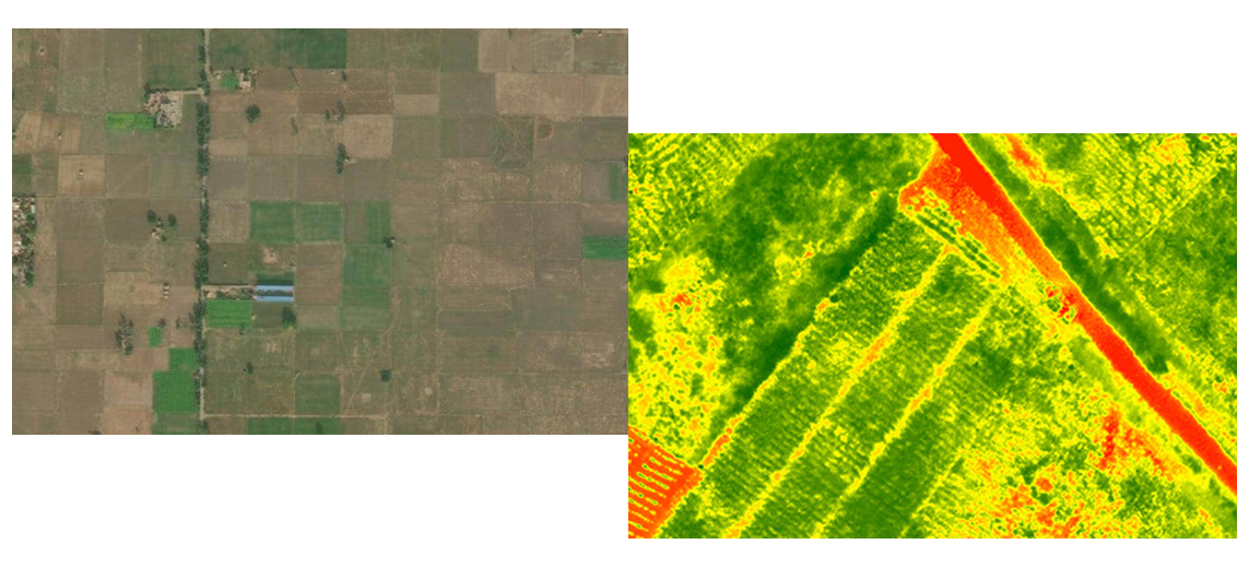
Crop Management
Product Delivered
- Digital Terrain Model
- Digital Surface Model
- Crop Growth Monitoring
- Field Characteristics
- Damage Detection
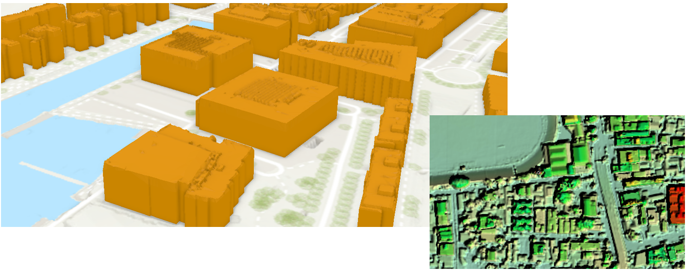
SMART CITY & URBAN MAPPING
Product Delivered
- Mobile & Aerial LiDAR Survey
- Topographic Map (1:300 scale) with 50 cm Contours
- 10 cm Orthophotos
- 360° Panoramic Imagery
- Property Tax Management
- Solar Rooftop Management
- Address Management
- Urban Forest Management
- Document complete Urban Assets
- Road Pothole Management
- Utility Asset Management
- 360° Panoramic Imagery/5 cm Ortho Imagery
- Integration with Asset Management Software
- Construction Progress Monitoring
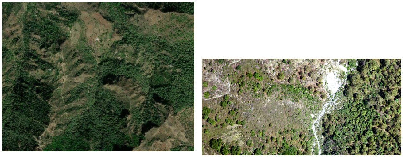
Forest Management
Product Delivered
- LiDAR Surveys – DEM/Contours
- Flood/Disaster Modelling
- Landslide Slope Analysis
- Catchment Area Study
- Soil & Moisture Conservation
- River Basin Rejuvenation/ Management
Land Records
Product Delivered
- High Resolution ORI.(5cm)
- Digital Surface Model
- Cadastral Maps
- Accurately Digitized map on ORI